
Home /
Selected Geology /
Palaeogeography
T. Alekseeva et al. (2016):
Characteristics
of Early Earth's Critical Zone Based on Middle—Late Devonian Paleosol Properties
(Voronezh High, Russia). In PDF,
Clays and Clay Minerals, 64: 677–694. https://doi.org/10.1346/CCMN.2016.064044.
Note also
here.
Note figure 13: Terrane map of western and central Laurussia (including the Laurentian sector) and adjacent areas in the late Devonian
(Famennian).
UT Institute for Geophysics,
The University of Texas at Austin,
The John A. and Katherine G. Jackson School of Geosciences:
Plate Tectonics News Archive.
See also:
The
PLATES Project.
Now provided by the Internet Archive´s Wayback Machine.
PLATES is a program of research into plate tectonic and geologic reconstructions.
PLATES maintains an up-to-date
oceanic magnetic and tectonic database, continuously adding new
paleomagnetic, hot spot, geological and
geophysical data to extend the span and accuracy of
global plate reconstructions.
You may navigate from
here.
AWI, Foundation Alfred Wegener Institute for Polar and Marine Research and MARUM, Center for Marine Environmental Sciences, Bremen: PANGAEA. The information system PANGAEA is a public data library on the Internet aimed at archiving, publishing and distributing geocoded data with special emphasis on environmental, marine and geological research. AWI and MARUM have commited to operate PANGAEA on a long-term basis. Go to: Software. The Software on this page is provided by the PANGAEA-Network for the visualization, exploration and interpretation of scientific data. The tools are freeware.
L. Azevedo-Schmidt et al. (2024):
Ferns
as facilitators of community recovery following biotic upheaval. Open access,
BioScience. https://doi.org/10.1093/biosci/biae022.
! Note figure 1: Time-calibrated fern phylogeny
[shows additionally major extinction events with and without fern spike].
See also
here.
"... The competitive success of ferns has been foundational to hypotheses about terrestrial
recolonization following biotic upheaval, from wildfires to the Cretaceous–Paleogene asteroid
impact (66 million years ago). Rapid fern recolonization in primary successional environments has been hypothesized
to be driven by ferns’ high spore production and wind dispersal
[...] We propose that a competition-based view of ferns is outdated and in need of reexamination ..."
!
Callan Bentley et al.:
Historical Geology
A free online textbook for Historical Geology courses.
The Museum of Paleontology (UCMP), University of California at Berkeley: Plate Tectonics. See the plate tectonics animation of the last 750 million years, using 1.44MB, 750KB or 350KB. Animation built from images provided by Christopher R. Scotese, PALEOMAP Project, U. Texas at Arlington.
! Museum of Paleontology (UCMP), University of California, Berkeley: UCMP Glossary. Terms in this glossaries are important to practicing biologists, palaeontologists and geologists in various fields. Go to: The glossary of paleogeographic terms.
Ron Blakey, Department of Geology, Northern Arizona University, Flagstaff:
Global
Earth History.
This presentation uses a series of plate-tectonic reconstructions to show the broad patterns of
Phanerozoic Earth history. Both horizontal and vertical links are provided for viewing the plates:
horizontal links provide time-slices (eg Cambrian, Devonian, Triassic, etc.) of different kinds of
data on maps and other illustrations whereas vertical links provide a dynamic portrayal of Earth
history through a succession of similar plate-tectonic
reconstructions.
Still available through the Internet Archive´s
Wayback Machine.
Ron Blakey,
Department of Geology, Northern Arizona University, Flagstaff:
!
Paleogeography
Through Geologic Time. Choose a geologic period and click on its name to view menu
of that time, then select the paleogeographic globe or a 1st order global tectonic feature.
Still available through the Internet Archive´s Wayback Machine.
R. Bos et al. (2023):
Triassic-Jurassic
vegetation response to carbon cycle perturbations and climate change. Free access,
Global and Planetary Change, 228.
Note figure 1: Paleogeographic reconstruction of the end-Triassic.
Figure 4. Major vegetation patterns as inferred by their botanical affinities.
Figure 5. Palynofloral diversity indices plotted against the variation of major botanical groups.
Figure 7. Depositional model of paleoenvironmental changes in the northern German Basin-
S. Bourquin et al. (2011): The Permian-Triassic transition and the onset of Mesozoic sedimentation at the northwestern peri-Tethyan domain scale: palaeogeographic maps and geodynamic implications. In PDF, Palaeogeography, Palaeoclimatology, Palaeoecology, 299: 265-280.
L. Brakebusch (2022):
Record
of the end-Triassic mass extinction in shallow marine carbonates: the Lorüns section
(Austria). In PDF,
Thesis, Department of Geology, Lund University.
Note figure 3: Palaeogeographic map of Pangaea.
Figure 21: Flow chart showing possible cascading effects of CAMP with respect to an
ocean acidification scenario.
"... The importance of the Lorüns section lies in
the continuous sedimentation from the late Rhaetian to
the Sinemurian, which gives the direct possibility to
study environmental conditions before, during and
after the ETE [end-Triassic mass extinction] ..."
!
S.D. Burley et al. (2023):
‘A
hard rain's a-gonna fall’: torrential rain, flash floods and desert lakes in the Late Triassic
Arden Sandstone of Central England. Open access,
Geology Today, 39.
!
Note figure 5: The Carnian world,
based on the PALEOMAP project, showing the distribution of
continents and ocean basins for the Late Triassic, active
subduction and spreading margins, and summer atmospheric circulation.
"... The Carnian age of the Arden Sandstone potentially links it to the Carnian Pluvial Episode,
marking the coalescence, spread and freshening of the formerly saline desert lakes, and
deposition of sandy, fluvial and lacustrine deposits, during the wetter climate that prevailed for
at least a million years ..."
!
W. Cao et al. (2017):
Improving
global paleogeography since the late Paleozoic
using paleobiology. In PDF,
Biogeosciences, 14: 5425–5439. See also
here, and especially
!
there.
(EarthByte, an internationally leading eGeoscience collaboration
between several Australian Universities, international centres of excellence and industry partners.
E. Capel et al. (2023): New insights into Silurian–Devonian palaeophytogeography. Free access, Palaeogeography, Palaeoclimatology, Palaeoecology. 613.
Rick Cheel, Department of Earth Sciences, Brock University:
Geologic
Time and
Historical
Geology and the history of the continents.
Powerpoint presentations.
These expired links are now available through the Internet Archive´s
Wayback Machine.
Stanley Chernicoff et al.;
Earth: Geologic Principles and History:
Chapter
23. The Geology of the Mesozoic Era.
Powerpoint presentation.
Department of the Geophysical Sciences, University of Chicago: Paleogeographic Atlas Project. Using the data bases and their own specially designed software, the Paleogeographic Atlas Project scientists construct paleomaps of the Earth (the paleogeology of the past 250 million years). These "snapshots" contain detailed geologic information - the height of mountains, depth of oceans, even clues to ancient climate - compiled from field work by geologists and paleontologists working around the world.
!
Deep Time Maps
(produced by Colorado Plateau Geosystems, Inc.).
The maps show the varied landscapes of the ancient Earth through hundreds of millions
of years of geologic time including distribution of ancient shallow seas, deep ocean basins,
mountain ranges, coastal plains, and continental interiors.
Worth checking out:
Paleogeography
of Europe
(Europe Series Thumbnails).
!
X. Delclos et al. (2023):
Amber
and the Cretaceous Resinous Interval. Free access,
Earth-Science Reviews, 243.
Note figure 2 (palaeogeographical maps): Distribution of resiniferous
forests based on known amber-bearing localities and known occurrences of potential coniferous resin-producing tree
families throughout the Cretaceous.
Figure 4: Oxygen (O2) and carbon dioxide (CO2) atmospheric composition, temperature, and Large
Igneous Province (LIP) activity throughout the Cretaceous.
"... Here we discuss the set of interrelated abiotic and biotic factors potentially involved in resin production
during that time. We name this period of mass resin production by conifers during the late Mesozoic, fundamental as an
archive of terrestrial life, the ‘Cretaceous Resinous Interval’ (CREI) ..."
! J. Dercourt et al. (2000): Peri-Tethys Atlas palaeogeographical maps. In PDF, Commission de la Carte G´eologique du Monde, Paris. See here as well.
!
The Digital
Encyclopedia of Ancient Life (DAoAL). Managed by the
Paleontological Research Institution, Ithaca, New York.
The original goal of the DAoAL project was to provide free resources to help individuals
identify and better understand fossil species from particular regions and time intervals.
J.M. Drovandi et al. (2024):
The
southwesternmost record of late Silurian (Pridolian) early land plants of Gondwana. In PDF,
Scientific Reports, 14.
Also
available here.
Please note figure 7: Paleogeographic reconstruction of the continents during the interval Ludlow-Pridoli.
"... The association between flora remains and graptolites, represents a
parautochthonous assemblage in an
inner marine platform, dominated by gravity flows. This record has
paleophytogeographic importance
indicating the extension of the northwest Gondwana-southern Laurusia
unit to more southern areas
of Gondwana ..."
Brandon Dugan and Carrie Masiello, Earth, Environmental and Planetary Sciences,
Rice University, Houston, TX:
Evolution
of the Earth. Lecture notes, Powerpoint presentations.
!
You may navigate from
here,
e.g.:
Lecture 2,
Dynamic and Evolving Earth.
Lecture 3, Dynamic
and Evolving Earth. Many paleogeographical maps!
Lecture 8, Understanding
Geologic Time.
Lecture 25, Late
Paleozoic Earth History.
SE Asia Research Group, Department of Geology, Royal Holloway University of London, Egham, Surrey, U.K.: Palaeogeographic Maps of SE Asia.
S. Feist-Burkhardt et al. (2008): 13 Triassic (starting on page 749). In: Tom McCann (ed.): The Geology of Central Europe: Mesozoic and Cenozoic: Vol. 2. The Geological Society, London.
GeologieInfo.de (Michael Wegner, Köln):
!
Historische Geologie,
Paläoklima.
Palaeogeographic maps (based on Scotese 2000) with palaeoclimate symbols.
In German.
Geology.com (published by Hobart King): Teaching Plate Tectonics with Easy-to-Draw Illustrations.
By GEOMAR, Research Center for Marine Geosciences / Kiel and the Geological Institute of the University Bremen: Ocean Drilling Stratigraphic Network (ODSN), ODSN Plate Tectonic Reconstruction Service. Calculate platetectonic reconstructions of any age back to 150 My. A Plate Tectonic Animation (330 kb) using 5 my timesteps is available too.
Y. Goddéris et al. (2014): The role of palaeogeography in the Phanerozoic history of atmospheric CO2 and climate. In PDF, Earth-Science Reviews, 128: 122-138.
Jan Golonka (2007): Phanerozoic paleoenvironment and paleolithofacies maps. Mesozoic. PDF file, Geologia, 33: 211-264.
Google: Science > Earth Sciences > Paleogeography and Paleoclimatology. Now available by the Internet Archive´s Wayback Machine.
handprint media: The Geological Evolution of the Earth. This web site presents in a vertical time line images of the Earth's geologic evolution from 510 million years ago to the present.
Colin Harris, UK:
Geology Shop.
A link directory (introductory website slow loading), comprising over 70 individual web pages. Go to:
Palaeogeographic Reconstructions.
Bruce C. Heezen and Marie Tharp,
Tectonic Designs, (page hosted by SIMall.com):
World Ocean Floors.
Unfortunately in small size 8.91 x 4.83 cm, 150 dpi (jpg).
This amazing piece of work accurately illustrates the tectonic Earth including mid-ocean ridges,
the giant Pacific Plate, continental shelves, and undersea mountain chains.
The link is to a version archived by the Internet Archive´s Wayback Machine.
!
hhmi BioInteractive
(The Howard Hughes Medical Institute (HHMI)).
BioInteractive is a leading provider of free classroom resources and professional development
for high school and undergraduate biology educators.
!
EarthViewer.
This interactive module allows to explore the science of Earth's deep history,
from its formation 4.5 billion years ago to modern times.
Excellent!
Stephen D. Hopper (2009):
OCBIL
theory: towards an integrated understanding
of the evolution, ecology and conservation of biodiversity
on old, climatically buffered, infertile landscapes. PDF file,
Plant Soil, 322: 49-86.
See likewise
here.
J. Hošek et al. (2024):
Hot
spring oases in the periglacial desert as the Last Glacial Maximum refugia for temperate trees
in Central Europe. Free access,
Science Advances, 10, eado6611.
Note figure 1: European paleoenvironments during the LPG (~28 to 14.7 ka).
!
A. Iglesias et al. (2011):
The
evolution of Patagonian climate and vegetation from the Mesozoic to the present. Free access,
Biological Journal of the Linnean Society, 103: 409–422.
Note fig. 1: Geographical, climatologic and biome evolution for
Gondwana and southern South America.
Journal
of Palaeogeography.
This journal (open access) aims to introduce the latest results in palaeogeography.
M. Alan Kazlev, Palaeos, Australia: Pangea.
! Kieseltorf.de: Timetable. Clickable palaeogeographic maps.
! W.J. Kious and R.I. Tilling,
U.S. Department of the Interior, U.S. Geological Survey:
This dynamic earth:
The story of plate tectonics.
You can also download a PDF version
(3.75 MB).
Snapshot taken by the Internet Archive´s Wayback Machine.
W. Lestari et al. (2023):
Carbon
Cycle Perturbations and Environmental Change of the Middle Permian and Late Triassic
paleo-Antarctic Circle. Free access,
Researchsquare.
See likewise
here.
Note figure 1: Permian and Triassic paleogeographical maps of the Southern Hemisphere.
"... The Bicheno-5 core from Eastern Tasmania, Australia, provides the opportunity to examine
Mid-Permian and Upper Triassic sediments from the paleo-Antarctic, using high-resolution organic
carbon isotope (d 13 C TOC) chemostratigraphy, pXRF, and sedimentology,
combined with new palynological data integrated with the existing radiometric age model ..."
University of London External System, London, UK (This is is a division of the University of London that grants external degrees: Study in Economics, Management, Finance and Social Sciences (EMFSS), Biogeography. Go to: Chapter 4: Patterns in time. This PDF file briefly reviews the evolution of the flora and fauna of the earth and the role that plate tectonics, climate and sea level played in their evolution.
D.-W. Lü et al. (2024):
A
synthesis of the Cretaceous wildfire record
related to atmospheric oxygen levels? Open access,
Journal of Palaeogeography, 13: 149-164.
"... In this study, we comprehensively synthesize a total of 271 published Cretaceous
wildfire occurrences based on the by-products of burning, including fossil charcoal,
pyrogenic inertinite (fossil charcoal in coal), and pyrogenic polycyclic aromatic hydrocarbons
(PAHs). Spatially, the dataset shows a distinctive distribution of reported wildfire
evidence characterized by high concentration in the middle latitudinal areas of the
Northern Hemisphere ..."
S.G. Lucas (2023):
Permophiles
Perspective: Nonmarine Permian
Biostratigraphy, Biochronology and Correlation. In PDF,
Permophiles.
Note figure 1: Map of Pangea at 270 Ma.
!
S.G. Lucas et al. (2023):
An
introduction to ice ages, climate dynamics and biotic events: the Late Pennsylvanian world. Open access,
Geological Society, London, Special Publications, 535.
Note figure 2: Late Pennsylvanian palaeogeographical map.
Figure 5: Reconstructions of Desmoinesian and Missourian age peat-forming swamp vegetation.
J. Marmi et al. (2023): Evolutionary history, biogeography, and extinction of the Cretaceous cheirolepidiaceous conifer, Frenelopsis. Free access, Evolving Earth, 1.
! Ellen E. Martin, Department of Geology, University of Florida: Global Climate Change. Lecture notes (powepoint presentations). Navigate from here or there. See especially: General Overview. Phanerozoic Palaeoclimate. Including some palaeogeographic maps.
!
I.P. Montañez and C.J. Poulsen (2013):
The
Late Paleozoic ice age: an evolving paradigm. In PDF,
Annual Review of Earth and Planetary Sciences, 41.
See likewise
here.
Note figure 1: Mollweide paleogeographic maps of (a) the Late Mississippian (340 Mya)
early icehouse and (b) the Early Pennsylvanian (300 Mya) peak icehouse.
"... The late Paleozoic icehouse was the longest-lived ice age of the Phanerozoic
[...] This review summarizes evidence for the timing, extent, and behavior of continental ice on Pangea in addition to the climate and ecosystem
response to repeated transitions between glacial and interglacial conditions ..."
!
I.P. Montañez (2021):
Current
synthesis of the penultimate icehouse and its imprint on the Upper Devonian through
Permian stratigraphic record. In PDF,
Geological Society, London, Special Publications, 512: 213-245. See also
here
(free access).
Note fig. 2: Palaeogeographical distribution of glaciated basins in Gondwana.
Palaeobotanical Research Group, Münster, Westfälische Wilhelms University, Münster, Germany.
History of Palaeozoic Forests,
PALAEOZOIC PALAEOGEOGRAPHY.
Link list page with picture rankings. Explore the Palaeozoic world and see continents move through time and space, and learn about climate
and vegetation.
The link is to a version archived by the Internet Archive´s Wayback Machine.
!
R.D. Nance (2022):
The
supercontinent cycle and Earth's long-term climate. Open access,
Annals of the New York Academy of Sciences, 1515: 33–49.
Note figure 1: Reconstruction of Pangea for the Late Triassic (at 200 Ma).
!
Figure 7: Distribution of warm (greenhouse) and cool (icehouse) global climatic conditions for the
past 1 Ga compared with times of
supercontinent assembly and breakup for Rodinia, Pannotia, and Pangea.
Figure 9: Distribution of large igneous provinces (LIPs) throughout Earth history.
!
Figure 10: Age and estimated volume of Phanerozoic large igneous provinces
(LIPs) compared to genus extinction magnitude showing
correlation between mass extinction events (peaks) and LIP emplacement.
NASA:
The
Digital Tectonic Activity Map (DTAM).
See also:
P. Lowman et al. (1999):
A
Digital Tectonic Activity Map of the Earth
(in PDF).
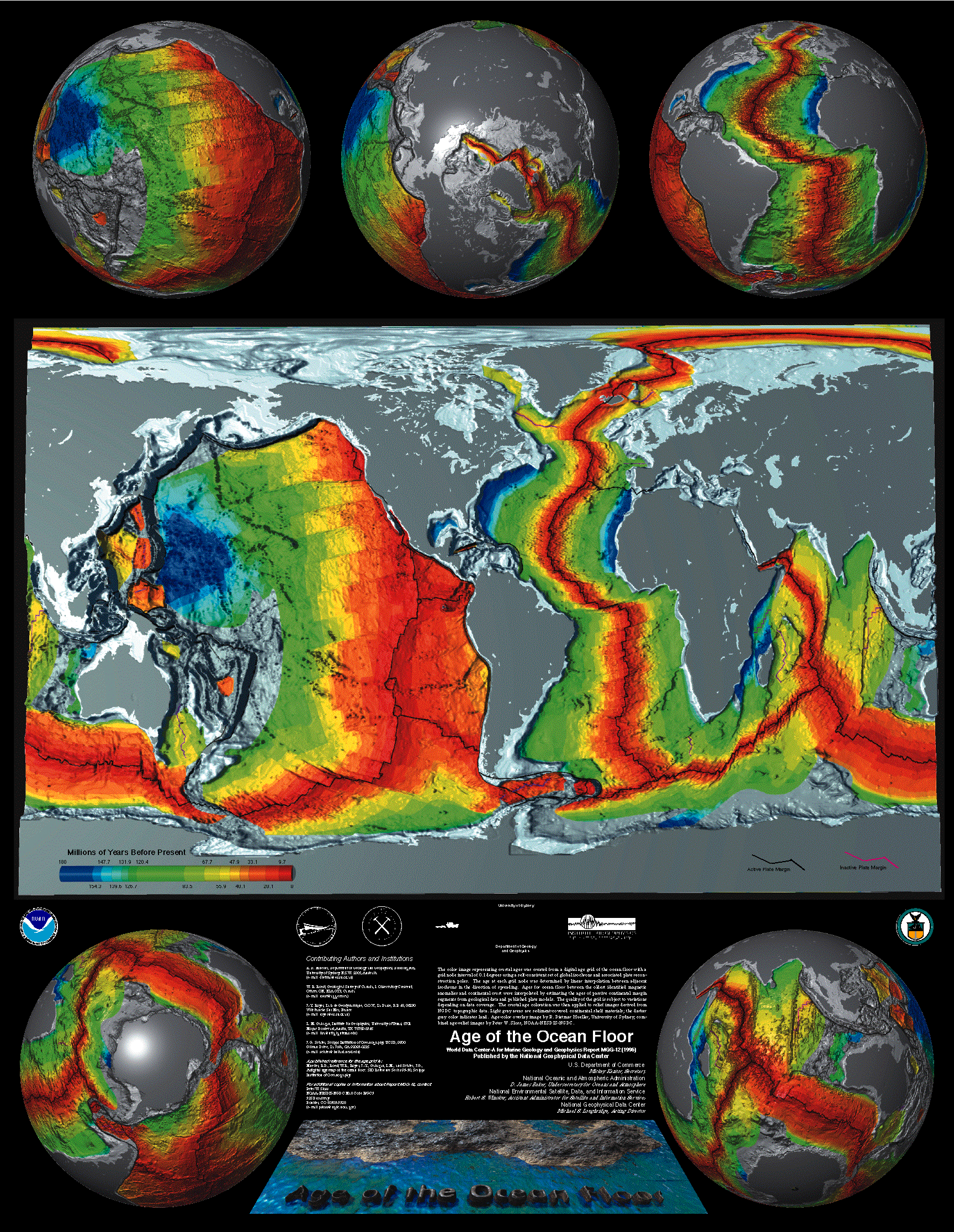
The National Geophysical Data Center: World Data Center for Marine Geology & Geophysics, Boulder; AGE OF THE OCEAN FLOOR POSTER. The poster offered by NGDC are a composite of topographic and bathymetric data available from NGDC and crustal age data. Have a look for (or download) the really enlarged view (1.6 MG GIF file).
Nederlandse Vereniging voor Kartografie:
Gondwana.
Shockwave and GIF plate tectonic animations.
To see the evolution of Australia,
Antarctica, Africa, and India with attendant faults and hot spots,
go to the
animated GIF version on-line.
Websites outdated. Links lead to versions archived by the Internet Archive´s Wayback Machine.
Ocean
Drilling Stratigraphic Network (ODSN), by GEOMAR,
Research Center for Marine Geosciences / Kiel and the
Geological Institute of the University Bremen:
ODSN
Plate Tectonic Reconstruction Service.
In this section you can calculate platetectonic reconstructions of any age back to 150 My.
J.G. Ogg et al. (2019): Global Paleogeography through the Proterozoic and Phanerozoic: Goals and Challenges. Acta Geologica Sinica (English Edition), 93: 59-60. See also here.
Kyoko Okino, Ocean Research Institute,
University of Tokyo:
Plate
Motion Calculator.
The prototype of web-based plate motion calculator was developed by K. Tamaki.
This calculator is a revised version by K. Okino.
!
The Paleobiology Database (PBDB).
PBDB is a public database of paleontological data that anyone can use, maintained by an international
non-governmental group of paleontologists.
The Paleobiology Database has been supported by many grants over the years, mostly from the
National Science Foundation. You may navigate from the
Paleobiology
Database Guest Menu or check out the
Frequently
Asked Questions. Please also note the detailed and excellent tutorial:
!
M.D. Uhen et al. (2023):
Paleobiology
Database User Guide Version 1.0 Free access,
PaleoBios, 40: 1-56.
See also
here
(in PDF).
The Paleobiology Database (PaleoBioDB): Organized and operated by
a multi-disciplinary, multi-institutional, international group of paleobiological researchers.
The PaleobiologyPaleoBioDB is a non-governmental, non-profit public resource
for paleontological data. Go to:
!
PaleoBioDB API.
The Paleobiology Database Application Programming Interface (API) gives
access to taxonomic, spatial, and temporal data. See especially:
Navigator.
Space, time and taxa.
Paleogeographic Atlas Project, University of Chicago:
Jurassic
Floras and Climate.
Website outdated. The link is to a version archived by the Internet Archive´s Wayback Machine.
Pangaea (an independent, international publisher): Alfred Wegner (1880-1930). A biographical note.
£. Pawlik et al. 2020):
Impact
of trees and forests on the Devonian
landscape and weathering processes with implications to the global Earth's system
properties – A critical review. In PDF,
Earth-Science Reviews, 205: doi 10.1016/j.earscirev.2020.103200.
See also
here.
Note fig. 2. Spatial configuration of continents in the Devonian.
Note fig. 3: Landscape reconstruction with stands of Pseudosporochnus, up to 4 m high, with
Protopteridium in shruby layer and herbaceous Drepanophycus
and Protolepidodendron in understorey.
Note fig. 6: A close look at trees diversification and selected accompanying events
in the Devonian.
Peabody Museum of Natural History, Yale University:
Geologic
Time Scale. Powerpoint presentation.
!
A. Pohl et al. (2022):
Dataset
of Phanerozoic continental climate and Köppen–Geiger climate classes. Free access,
Data in Brief, 43.
See also
here.
"... This dataset provides a unique window onto changing continental
climate throughout the Phanerozoic that accounts for the simultaneous evolution of paleogeography. ..."
!
Note figure 3: Overview of 28 Phanerozoic time slices.
R. Prevec et al. (2022):
South
African Lagerstätte reveals middle Permian Gondwanan lakeshore
ecosystem in exquisite detail. Open access,
Communications Biology, 5.
Note figure 1: Climatic zones for the Wordian of Pangea including locations of middle Permian fossil insect
discoveries.
Figure 6: Reconstruction of a middle Permian lakeshore palaeoenvironment.
J. Pšenicka et al. (2021):
Dynamics
of Silurian plants as response to climate changes. Open access,
Life, 11.
Note figure 1: Silurian time scale showing conodont and graptolite biozones,
stage slices and
generalized 13Ccarb curve.
Figure 2: Silurian palaeocontinental reconstructions.
W. Qie et al. (2023):
Enhanced
Continental Weathering as a Trigger for the End-Devonian Hangenberg Crisis. Open access,
Geophysical Research Letters, 50: e2022GL102640.
Note figure 1A: Latest Devonian global paleogeographic reconstruction.
"... The colonization of land plants during the Devonian is believed to have
played a key role in regulating Earth's climate. The initially rapid expansion of
seed plants into unvegetated or
sparsely vegetated uplands is considered to have caused enhanced rock dissolution
relative to clay formation on end-Devonian continents ..."
Rasmussen College: A Beginner's Guide to Plate Tectonics. A version archived by Internet Archive Wayback Machine.
P.M. Rees et al. (2002):
Permian
Phytogeographic Patterns and Climate
Data/Model Comparisons.
PDF file, Journal of Geology, 110, 1–31.
See also
here.
P.M. Rees et al. (2002):
Permian Phytogeographic Patterns and Climate
Data/Model Comparisons.
PDF file.
The link is to a version archived by the Internet Archive´s Wayback Machine.
See also
here and
there.
! Allister Rees,
Department of Geosciences,
University of Arizona, Tucson:
Mesozoic.
Mesozoic topics - including PDF files - are:
Jurassic phytogeography and climates (data and models);
Late Jurassic climate, vegetation and dinosaur distribution;
Mesozoic assembly, Asia: floras, tectonics, paleomagnetism;
Paleoecology, middle Cretaceous Grebenka flora, Siberia; and
Lower Jurassic floras of Hope Bay & Botany Bay, Antarctica.
See also:
PGAP Paleogeographic Maps
(downloadable pdf files).
Archived by the Internet Archive´s Wayback Machine.
Allister Rees, Department of Geosciences, University of Arizona, Tucson:
PaleoIntegration Project (PIP).
The Paleointegration Project is facilitating interoperability
between global-scale fossil and sedimentary rock databases,
enabling a greater understanding of the life,
geography and climate of our planet throughout the Phanerozoic. Go to:
Mesozoic.
These expired links are now available through the Internet Archive´s
Wayback Machine.
! Allister Rees,
Department of Geosciences,
University of Arizona,
Tucson:
Paleobiography
Project. Now recovered from the Internet Archive´s
Wayback Machine.
There are
three databases, including
a map-based search function, plotting on paleomaps, references
search, genus name search for the dinosaurs and plants, and tutorial pages:
PGAP, the Paleogeographic Atlas Project Lithofacies Database.
Mesozoic and Cenozoic Lithofacies.
CSS, the Climate Sensitive Sediments Database.
Permian and Jurassic Climate Sensitive Sediments.
DINO, the Dinosauria Distributions Database.
Triassic, Jurassic and Cretaceous Dinosaur Distributions.
!
Allister Rees,
Department of Geosciences,
University of Arizona,
Tucson:
Mesozoic.
Mesozoic topics - including PDF files - are:
Jurassic phytogeography and climates (data and models);
Late Jurassic climate, vegetation and dinosaur distribution;
Mesozoic assembly, Asia: floras, tectonics, paleomagnetism;
Paleoecology, middle Cretaceous Grebenka flora, Siberia; and
Lower Jurassic floras of Hope Bay & Botany Bay, Antarctica.
The link is to a version archived by the Internet Archive´s Wayback Machine.
Allister Rees, Fred Ziegler and
David Rowley, University of Chicago:
THE PALEOGEOGRAPHIC
ATLAS PROJECT (PGAP).
This expired link is now available through the Internet Archive´s
Wayback Machine.
Including a
Jurassic and Permian slideshow sampler (QuickTime),
paleogeographic maps (downloadable pdf files), and a bibliography of
PGAP Publications (with links to abstracts).
See also
the
new Paleogeographic Atlas Project website.
Allister Rees,
Department of Geosciences,
University of Arizona,
Tucson:
Permian
Phytogeography and Climate Inference.
Downloadable PowerPoint Presentation, Nonmarine Permian Symposium.
Still available via Internet Archive Wayback Machine.
I. Rodríguez-Barreiro et al. (2023):
Palynological
reconstruction of the habitat and diet of Iguanodon bernissartensis in the Lower
Cretaceous Morella Formation, NE Iberian Peninsula. Free access,
Cretaceous Research, 156.
Note figure 1: Paleogeographical map of western Europe for the late
Barremian-early Aptian interval.
"... To elucidate the paleoenvironment of the Palau-3 site, a palynological analysis was carried out
on matrix samples collected from around the skeleton.
The palynological assemblage is found to correspond to an upper Barremian age.
[...] the palynoflora is mostly dominated by the Cheirolepidiaceae conifer (Classopollis)
and Anemiaceae fern (mainly Cicatricosisporites) families. The absence of
angiosperm pollen in this flora is also noteworthy ..."
François Rosselet,
Section des Sciences de la Terre, Lausanne, Switzerland:
Tethyan
Plate Tectonic Home Page.
Tethyan plate reconstructions and descriptions.
Retrieved from the Internet Archive's Wayback Machine.
!
T. Salles et al. (2023):
Landscape
dynamics and the Phanerozoic diversification of the biosphere. Free access,
Nature, 624: 115–121.
Note figure 1: Physiographic evolution and associated patterns of erosion–deposition
across the Phanerozoic.
Figure 4: Continental sediment deposition and physiographic complexity,
and diversity of vascular plants, during the Phanerozoic.
"... we couple climate and plate tectonics models to numerically reconstruct the evolution of the
Earth’s landscape over the entire Phanerozoic eon, which we then compare to palaeodiversity
datasets from marine animal and land plant genera. Our results indicate that
biodiversity is strongly reliant on landscape dynamics
[...] On land, plant expansion was hampered by poor
edaphic conditions until widespread endorheic basins resurfaced continents with a
sedimentary cover that facilitated the development of soil-dependent rooted flora ..."
I. Sanmartín and F. Ronquist (2004): Southern Hemisphere Biogeography Inferred by Event-Based Models: Plant versus Animal Patterns. PDF file, Syst. Biol., 53: 216-243.
! A. Schettino. Istituto Tecnico Industriale e Liceo Scientifico Tecnologico "Ettore Molinari", Milano: Plate Tectonic Reconstructions. On-line paleogeographic reconstruction tool.
J.W. Schneider and R. Rößler (2023):
The
Early History of Giant Cockroaches: Gyroblattids and Necymylacrids (Blattodea)
of the Late Carboniferous. Free access,
Diversity, 15. https://doi.org/10.3390/d15030429.
!
Note figure 1: Stratigraphy of the oldest known winged insects (red star), oldest known blattoid insects
(green star), and important Late Paleozoic entomofaunas.
Figure 2: Late Carboniferous, Moscovian to Gzhelian, Euramerican orogenic belts and basins.
C.R. Scotese et al. (2025): The Cretaceous world: plate tectonics, palaeogeography and palaeoclimate. Open access, Geological Society, London, Special Publications, 544.
!
C.R. Scotese (2021):
An
atlas of Phanerozoic paleogeographic maps: the seas come in and the seas go out. In PDF,
Annual Review of Earth and Planetary Sciences, 49: 679-728.
See also
here.
Note chapter 4.5. Permo–Triassic (starting on PDF page 692).
! Figure 12:
A Paleozoic paleotemperature timescale.
! Figure 15:
A Mesozoic paleotemperature timescale.
! Figure 19:
A Cenozoic paleotemperature timescale.
C.R. Scotese and N. Wright (2018):
!
PALEOMAP
Paleodigital Elevation Models
(PaleoDEMS) for the Phanerozoic PALEOMAP Project.
A digital representation of paleotopography and paleobathymetry.
The paleoDEMS describe the changing distribution of deep oceans, shallow seas, lowlands,
and mountainous regions during the last 540 million years at five million year intervals.
See also
here
(in PDF). See especially:
!
Atlas
of Permo-Triassic Paleogeographic Maps (Mollweide Projection). In PDF,
Maps 43-52, Volumes 3 & 4 of the PALEOMAP Atlas for ArcGIS, PALEOMAP Project, Evanston, IL.
!
PaleoDEM
Resource – Scotese and Wright.
A complete set of the PALEOMAP PaleoDEMs can be downloaded.
! C.R. Scotese, Paleomap Project: Scotese's Palaeogeographic and Palaeotectonic Reconstructions of the World. An educational online resource for R. Leinfelder's University Lecture "Historical Geology - System Earth". You can purchase these and other animations via www.scotese.com.
! Christopher R. Scotese: Paleomap Project. A version archived by Internet Archive Wayback Machine. Travel back through time and check out what the earth looked like during the Paleozoic, Mesozoic and Cenozoic eras, and what it may look like far into the future.
!
L. Shao et al. (2024):
Inertinite
in coal and its geoenvironmental significance: Insights
from AI and big data analysis. In PDF,
Science China Earth Sciences, 67: 1779-1801. https://doi.org/10.1007/s11430-023-1325-5
See there as well.
Note figure 1: Annual publications about inertinite and palaeowildfire from 2000 to 2023.
Figure 6: Trends in atmospheric oxygen content since the Silurian.
Figure 9: Changes of inertinite and palaeoclimatic parameters in geological history.
Figure 17: Schematic model illustrating possible relationships between
frequent and intense forest fires and catastrophic sediment erosion,
river transport systems, and their potential consequences for the terrestrial
and marine ecosystems.
"... The distribution of inertinite in coals varied over different geological periods,
being typified by the “high
inertinite content-high atmospheric oxygen level” period in the Permian and the “low
inertinite content-low atmospheric oxygen
level” period in the Cenozoic. This study has proposed a possible model of the positive and
negative feedbacks between inertinite
characteristics and palaeoenvironmental factors ..."
!
G.R. Shi and J.B. Waterhouse (2010):
Late
Palaeozoic global changes affecting high-latitude environments and biotas: an introduction.
In PDF, Palaeogeography, Palaeoclimatology, Palaeoecology, 298: 1-16.
Still available through the Internet Archive´s
Wayback Machine.
See here
as well.
Note figure 3: A reconstruction of Late Permian world.
Figure 4 (A)–(C): Palaeogeographic evolution of the world from
early Carboniferous to Late Permian.
"... This introductory paper is designed to provide a global context for the special issue,
with a brief review of key late Palaeozoic global environmental changes (including: changes in
global land-sea configurations,
atmospheric chemistry, global climate regimes, global ocean circulation
patterns and sea levels) and largescale biotic (biogeographic and evolutionary)
responses, followed by a summary of what we see as unresolved scientific issues ..."
! Smithsonian Institution, Global Volcanism Program:
This
Dynamic Planet.
The map is designed to show Earth's most prominent features when viewed from a
distance, and more detailed features upon closer inspection
(interactive mapping functions, including zoom). See also
here
(U.S. Department of the Interior, U.S. Geological Survey), or
there
(Tom Simkin et al., 1994:
This Dynamic Planet:
World Map of Volcanoes, Earthquakes,
Impact Craters, and Plate Tectonics). In PDF.
G.S. Soreghan et al. (2023):
Dust
and loess as archives and agents of climate and climate change in the late
Paleozoic Earth system. Free access.
From: Lucas, S. G., DiMichele, W. A., Opluštil, S. and Wang, X. (eds.), 2023: Ice Ages, Climate Dynamics and Biotic
Events: the Late Pennsylvanian World. Geological Society, London, Special Publications, 535: 195–223.
Note Figure 1: Pangaea configurations for the early Permian (c. 290 Ma).
Figure 4: Provenance and palaeogeography of western equatorial Pangaea.
"... Palaeo-loess and silty aeolian-marine strata are well recognized across the Carboniferous–Permian
of equatorial Pangaea. Aeolian-transported dust and loess appear in the Late Devonian in the west, are common
by the Late Carboniferous, and predominate across equatorial Pangaea by the Permian
[...] The late Paleozoic was Earth’s largest and most long-lived dust bowl ..."
South
Carolina Geological Survey.
Education and Outreach.
Downloadable Earth Science
Education presentations, posters, and handouts. Go to:
Geologic
Time and Earth’s Biological History. Powerpoint presentation. Also
available in PDF.
! G.M. Stampfli, et al., Institute of Geology and Paleontology, University of Lausanne, Switzerland: Global Reconstruction and Database Project. Also available in PDF (10.7 MB).
Kensaku Tamaki, Ocean Research Institute, University of Tokyo: Absolute Plate Motion Calculator. A version archived by Internet Archive Wayback Machine. Select name of concerned plate, input latitude and longitude of the point on the plate, and press the button of "Execute calculation". Then you will get the velocity and motion direction at the point in a hotspot reference frame.
A.R. Tasistro-Hart and F.A. Macdonald (2023): Phanerozoic flooding of North America and the Great Unconformity. Free access, Proceedings of the National Academy of Sciences, 120. https://doi.org/10.1073/pnas.2309084120.
Mark Torrence, Raytheon Information Technology and Scientific Services Corporation, Greenbelt, Ben Chao and John W. Robbins, NASA: Tectonic Plate Motion from space geodesy. The results you will find here only represent the generally slow and smooth nature of tectonic motion.
! T.H. Torsvik and L.R.M. Cocks (2004): Earth geography from 400 to 250 Ma: a palaeomagnetic, faunal and facies review. In PDF, Journal of the Geological Society, 161: 555-572. See also here.
UNAVCO (a non-profit membership-governed consortium, facilitates geoscience research and education using geodesy): Plate Motion Calculator. This program is for the calculation of tectonic plate motion at any location on Earth using one or more plate motion models.
Urwelt-Museum Hauff
(Hauff Museum of the Prehistoric World), Holzmaden, Germany:
Die Geologische Uhr.
The geological clock, a downloadble Flush Plug In (in German).
See also
here
Snapshot taken by the Internet Archive´s Wayback Machine.
Faculty of Earth Sciences, Utrecht University: Plate Motion Calculator.
!
V. Vajda and A. Bercovici (2014):
The
global vegetation pattern across the Cretaceous–Paleogene mass extinction interval: a template
for other extinction events. Free access,
Global and Planetary Change, 122: 29-49.
Note figure 3: Paleogeographic map 66 Ma.
"... The Cretaceous–Paleogene boundary clay, associated with the Chicxulub
asteroid impact event, constitutes a unique,
global marker bed enabling comparison of the world-wide palynological signal spanning
the mass extinction
event. The data from both hemispheres are consistent
[...] we recommend using the K–Pg event as a model and to
use relative abundance data for the stratigraphic definition of mass-extinction
events and the placement of
associated chronostratigraphic boundaries ..."
B. van de Schootbrugge et al. 2024):
Recognition
of an extended record of euglenoid cysts: Implications for the end-Triassic mass extinction.
Free access, Review of Palaeobotany and Palynology, 322.
Note figure 1: Reconstructed palaeographic map of the Triassic-Jurassic boundary interval.
"... We conclude that Chomotriletes is the valid senior synonym of a variety
of taxa, including Circulisporites, Pseudoschizaea, and Concentricystes
[...] Chomotriletes s.l. is considered
to be a cyst of a freshwater organism
[...] The presence of euglenoid cysts in association with the end-Triassic extinction fits
a scenario in which enhanced rainfall followed by strong soil erosion resulted in the release
and redeposition of Chomotriletes into shallow marine settings ..."
A. Vicente et al. (2024):
A
bioprovince for the Barremian–Aptian charophytes of the Central Tethyan Archipelago. Free access,
Cretaceous Research, 154.
See also
here
(in PDF):
Wikipedia, the free encyclopedia:
!
Category:Plate tectonics.
Kategorie:Plattentektonik
(in German).
Plate tectonics.
Plattentektonik (in German).
!
Category:Paleogeography.
Palaeogeography.
Kategorie:Geologie (in German).
Kategorie:Paläontologie
(in German).
Paläogeographie (in German).
Wikipedia, the free encyclopedia:
Harry Hammond Hess.
Alfred Wegner.
P. Wilf and R.M. Kooyman (2023):
Do
Southeast Asia's paleo-Antarctic trees cool the planet?
Note figure 2: Reference paleoglobes for the early Eocene (left), south polar
view with part of Patagonia at the bottom and Australia at the top, and early Miocene
(right), centered on Australia.
"... Many tree genera in the Malesian uplands have Southern Hemisphere
origins, often supported by austral fossil records
[...] Paleo-Antarctic trees, in all likelihood, have helped cool the planet
by occupying and contributing to the weathering and CO2
consumption of uplifted terranes in Malesia over the past c. 15 Myr ..."
!
Q. Wu wet al. (2024):
The
terrestrial end-Permian mass extinction in the paleotropics postdates the marine extinction. Free
access, Science Advances, 10.
Note figure 1: Location of study area.
Figure 2: Correlations of the EPME [end-Permian mass extinction] between terrestrial and
transitional coastal sections in Southwest China.
!
Figure 5: Global correlation of the EPME.
Figure 6: Schematic illustration of the terrestrial EPME process.
"...We present high-precision zircon U-Pb geochronology by the chemical abrasion–isotope
dilution–thermal ionization mass spectrometry technique on tuffs from terrestrial to
transitional coastal settings
[...] our results suggest that the terrestrial extinction occurred diachronously
with latitude, beginning at high latitudes during the late Changhsingian and progressing
to the tropics by the early Induan, spanning a duration of nearly 1 million years ..."
T. Yang et al. (2024):
Megafossils
of Betulaceae from the Oligocene of Qaidam Basin and their paleoenvironmental and
phytogeographic implications. Open access,
Plant Diversity, 44: 101-115.
Note figures 6, 7: Paleographic maps of the world during the late Paleogene.
|
Top of page Links for Palaeobotanists |
Search in all "Links for Palaeobotanists" Pages!
|