
Home /
All about Upper Triassic /
Triassic Palaeogeography
R. Aubrecht et al. (2017):
Provenance
of the Lunz Formation (Carnian) in the Western Carpathians,
Slovakia: Heavy mineral study and in situ LA–ICP–MS U–Pb detrital
zircon dating. In PDF,
Palaeogeography, Palaeoclimatology, Palaeoecology, 471: 233–253. See also
here
(abstract), and
there.
Please take notice: Fig. 23, paleogeographic scheme of Middle Carnian, showing probable provenance of the Lunz Formation
arenites and its relation to the Stuttgart Formation in the Central
European Basin.
!
G. Bachmann et al. (2010):
Triassic.
(Triassic stratigraphy, Facies and hydrocarbons of the southern Permian Basin Area (SPBA)).
In: Petroleum
Geological
Atlas of the Southern Permian Basin Area.
EAGE Publications, p. 149. ISBN 9789073781610.
See also
here
(PDF file, with table of contents)
and
there
(PDF file, GIS maps presented in the atlas).
J. Barnasch (2009): Der Keuper im Westteil des Zentraleuropäischen Beckens (Deutschland, Niederlande, England, Dänemark): diskontinuierliche Sedimentation, Litho-, Zyklo- und Sequenzstratigraphie. PDF file, in German. Thesis, University Halle, Germany. See also here.
P.D.W. Barnard (1973):
Mesozoic
floras. In PDF, Special Papers in Palaeontology, 12: 175-187.
See also
here.
G. Barth et al. (2018):
Marine
and terrestrial sedimentation across the T–J transition in the North
German Basin. In PDF,
Palaeogeography, Palaeoclimatology, Palaeoecology,
489: 74-94.
See also
here.
Note Fig. 1: Central European Basin (CEB) and working area.
A. Becker (2024):
Cyclicity
of the Lower Buntsandstein in the eastern part of the Central European
Basin: Implications for Early Triassic palaeogeography and for geochronological
calibration. Free access,
Journal of Palaeogeography.
https://doi.org/10.1016/j.jop.2024.01.002.
!
Note figure 1: Early Triassic palaeogeography maps.
C.A. Benavente et al. (2024):
Triassic
Gondwanan floral assemblages reflect paleogeography more than geologic time. Abstract,
Gondwana Research.
"... Combining these and existing geochronologic data with a newly assembled comprehensive
presence/absence dataset of palynomorphs from the Anisian-Norian of Gondwana, we demonstrate
that paleogeography (paleolatitude) has a significantly stronger correlation with taxonomic
composition of assemblages than does geologic time
[...] results imply that geography is an important null hypothesis in explaining differences
in early Mesozoic Gondwanan palynomorph assemblages, and that precise geochronologic age
constraints are important for refining the accuracy of Triassic palynomorph biochronology ..."
!
M.J. Benton (2018):
Hyperthermal-driven
mass extinctions: killing
models during the Permian–Triassic mass
extinction. In PDF,
Phil. Trans. R. Soc. A, 376. See also
here.
Note Fig. 3: Palaeogeographic map of the Permo-Triassic, showing the single supercontinent
Pangaea, modelled climate belts, and the distribution of
terrestrial tetrapods.
! M.J. Benton (2016): The Triassic. Open access, Current Biology, 26: R1214–R1218.
H.-P. Berners et al. (1984): Vom Westrand des Germanischen Trias-Beckens zum Ostrand des Pariser Lias-Beckens: Aspekte der Sedimentationsgeschichte. Jahresberichte und Mitteilungen des Oberrheinischen Geologischen Vereins, 66: 357-395. See also here (in PDF).
Ron Blakey,
Department of Geology, Northern Arizona University, Flagstaff:
!
Paleogeography
Through Geologic Time. Choose a geologic period and click on its name to view menu
of that time, then select the paleogeographic globe or a 1st order global tectonic feature.
See especially:
!
Triassic.
Still available through the Internet Archive´s Wayback Machine.
A.D. Bond et al. (2023):
Globally
limited but severe shallow-shelf euxinia during the end-Triassic extinction. Open access,
Nature Geoscience. https://doi.org/10.1038/s41561-023-01303-2.
Note figure 1: Triassic–Jurassic palaeogeography of the Tethyan shelf.
!
R. Bos et al. (2025):
A
high-resolution palynological and geochemical study of the end-Triassic mass-extinction
based on a new cored succession at Winterswijk (the Netherlands). Free access,
Geological Magazine, 161(e17): 1–19. https://doi.org/10.1017/S0016756824000323.
Note figure 2A: Palaeogeographic reconstruction depicting depositional regime of
NW Europe and positions of Triassic-Jurassic boundary sections.
"... A high-resolution palynostratigraphic dataset provides evidence for a late
Rhaetian vegetation assemblage that displays a stepwise decline of arborescent tree vegetation
that is transiently replaced by a community of ferns and fern allies
[...] Comparison of our findings with other contemporaneous European Triassic-Jurassic boundary
sections confirms the progression of the endTriassic extinction,
which exhibits a two-phased structure ..."
R. Bos et al. (2023):
Triassic-Jurassic
vegetation response to carbon cycle perturbations and climate change. Free access,
Global and Planetary Change, 228.
Note figure 1: Paleogeographic reconstruction of the end-Triassic.
Figure 4. Major vegetation patterns as inferred by their botanical affinities.
Figure 5. Palynofloral diversity indices plotted against the variation of major botanical groups.
Figure 7. Depositional model of paleoenvironmental changes in the northern German Basin-
R. Bos et al. (2023):
Climate-forced
Hg-remobilization driving mutagenesis in ferns in the aftermath of the end-Triassic extinction.
Free access, researchsquare.com.
"... We conclude that Hg injected by CAMP across the extinction was repeatedly remobilized from
coastal wetlands and hinterland areas during eccentricity-forced phases of severe hydrological
upheaval and erosion, focusing Hg-pollution in shallow marine basins ..."
S. Bourquin et al. (2011): The Permian-Triassic transition and the onset of Mesozoic sedimentation at the northwestern peri-Tethyan domain scale: palaeogeographic maps and geodynamic implications. In PDF, Palaeogeography, Palaeoclimatology, Palaeoecology, 299: 265-280.
S. Bourquin et al. (2007): The Permian-Triassic boundary and Early Triassic sedimentation in Western European basins: an overview. PDF file, Journal of Iberian Geology, 33: 221-236. See also here.
!
S.D. Burley et al. (2023):
‘A
hard rain's a-gonna fall’: torrential rain, flash floods and desert lakes in the Late Triassic
Arden Sandstone of Central England. Open access,
Geology Today, 39.
!
Note figure 5: The Carnian world,
based on the PALEOMAP project, showing the distribution of
continents and ocean basins for the Late Triassic, active
subduction and spreading margins, and summer atmospheric circulation.
"... The Carnian age of the Arden Sandstone potentially links it to the Carnian Pluvial Episode,
marking the coalescence, spread and freshening of the formerly saline desert lakes, and
deposition of sandy, fluvial and lacustrine deposits, during the wetter climate that prevailed for
at least a million years ..."
!
W. Cao et al. (2017):
Improving
global paleogeography since the late Paleozoic
using paleobiology. In PDF,
Biogeosciences, 14: 5425–5439. See also
here, and especially
!
there.
(EarthByte, an internationally leading eGeoscience collaboration
between several Australian Universities, international centres of excellence and industry partners.
L. Corecco et al. (2024):
Triassic
climate and the rise of the dinosaur empire in South America. In PDF,
Journal of South American Earth Sciences, 142.
Note here
as well.
Note figure 2: Triassic timescale and geography. A) The Triassic time scale (~50 Ma)
is delimited by two major mass extinctions. B) Global paleogeographic map of the
Triassic, presenting the major climatic belts and highlighting an arid
climate ‘dead zone’ (beige) of the Early Triassic.
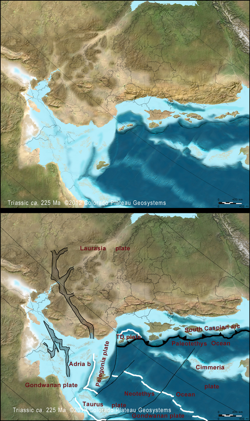
!
Deep Time Maps
(produced by Colorado Plateau Geosystems, Inc.).
The maps show the varied landscapes of the ancient Earth through hundreds of millions
of years of geologic time including distribution of ancient shallow seas, deep ocean basins,
mountain ranges, coastal plains, and continental interiors.
Worth checking out:
Paleogeography
of Europe
(Europe Series Thumbnails).
See especially:
!
Europe
Triassic ca. 225 Ma.
!
Europe
Triassic ca. 250 Ma.
Deutsche Stratigraphische Kommission:
!
International
Triassic Field Workshops.
An informal forum for earth scientists who are interested in the Triassic system. Go to:
!
Southern
Germany.
In PDF, by H. Hagdorn, T. Simon, E. Nitsch, T. Aigner.
!
Central
Germany.
In PDF, by G. H. Bachmann, G. Beutler.
C.G. Diedrich (2010): The development of the Middle Triassic tectonical controlled Germanic Basin of Central Europe and the palaeoenvironmental related distribution of marine and terrestrial reptiles. PDF file, Geophysical Research Abstracts, 12; EGU General Assembly 2010.
J. Enga (2015):
Paleosols
in the Triassic De Geerdalen and Snadd formations. In PDF,
Master thesis, Department of Geology and Mineral Resources Engineering,
Norwegian University of Science and Technology. See also
here.
Note figure 1.2: Late Triassic paleogeographic reconstruction of the Svalbard and Barents Sea
region.
"... Identification of paleosols has been based on recognition of features such as fossil roots in
growth position, color variations and horizons, pedogenic slickensides and organic
accumulations
[...] The paleosols attest to a dominantly humid climate with
a seasonal variation in precipitation ..."
! S. Feist-Burkhardt et al. (2008): 13 Triassic (starting on page 749). In: Tom McCann (ed.): The Geology of Central Europe: Mesozoic and Cenozoic: Vol. 2. The Geological Society, London.
J. Fischer et al. (2012):
Palaeoenvironments
of the late Triassic Rhaetian Sea: Implications from oxygen and
strontium isotopes of hybodont shark teeth. In PDF,
Palaeogeography, Palaeoclimatology, Palaeoecology, 353–355: 60–72. See also
here.
Note figure 1: Palaeogeographic and structural overviewmap of the late Triassic Central European Basin.
Figure 7. Schematic palaeogeographic map of the Central European Basin illustrating successive
freshening of the Rhaetian Sea from the gates to its eastern margins.
A. Förster et al. (2010):
Reservoir
characterization of a CO2 storage aquifer: The Upper Triassic Stuttgart
Formation in the Northeast German Basin. Abstract,
Marine and Petroleum Geology, 27: 2156-2172.
Note Fig. 3: Facies map of the Stuttgart Formation in northeastern Germany.
W.J. Foster et al. (2025):
An
unpredictable body size response to the Permo–Triassic climate crisis.In PDF,
EGUsphere.
Note figure 1: Palaeogeographic setting of the Dolomites, Italy.
"Shallow marine bivalve communities from the Dolomites in Italy show a significant reduction in body-size at the
genus-level, but conversely at the species-level body sizes stay the same or slightly increase, inconsistent with the
Lilliput effect hypothesis
[...] The impact of the mass extinction event on biotic
interactions also likely played a major role in the preferential
origination of small-sized species ..."
!
M. Franz et al. (2015):
Eustatic
and climatic control on the Upper Muschelkalk Sea
(late Anisian/Ladinian) in the Central European Basin. In PDF,
Global and Planetary Change, 135: 1-27.
See also
here
(abstract). Note:
Fig. 3: Reconstructions of the Upper Muschelkalk Sea.
Fig. 13: Ladinian North Pangaean palaeogeography,
showing depositional environments and inferred zonal climates.
M. Franz et al. (2014):
Eustatic
control on epicontinental basins: The example of the Stuttgart Formation in the
Central European Basin (Middle Keuper, Late Triassic.
Abstract, Global and Planetary Change, 122 :305-329. See also
here
(in PDF).
Please take notice: Fig. 1, Upper Triassic palaeogeography of the
Central European Basin according to Ziegler (1990).
M. Franz et al. (2012): The strong diachronous Muschelkalk/Keuper facies shift in the Central European Basin: implications from the type-section of the Erfurt Formation (Lower Keuper, Triassic) and basin-wide correlations. Abstract, International Journal of Earth Sciences.
!
Matthias Franz (2008), Martin-Luther-Universität Halle-Wittenberg:
Litho- und Leitflächenstratigraphie, Chronostratigraphie,
Zyklo- und Sequenzstratigraphie des Keupers im östlichen Zentraleuropäischen
Becken (Deutschland, Polen) und Dänischen Becken (Dänemark, Schweden).
Thesis, in German. Available in
PDF, 39,5 MB.
Note
page 47, fig. 5.1.1-2: Sandstone S 1.
page 51, fig. 5.1.1-3: Grenzdolomit.
page 53, fig. 5.1.2: Grabfeld-Formation.
page 59, fig. 5.1.3: Stuttgart-Formation.
page 64, fig. 5.1.4-1: Weser-Formation.
page 67, fig. 5.1.4-2: Hauptsteinmergel.
page 71, fig. 5.1.4-3: Heldburgips.
page 76, fig. 5.1.5-1: Arnstadt-Formation.
page 79, fig. 5.1.5-2: Lower Arnstadt-Formation.
page 91, fig. 5.2.3: Exter-, Seeberg- und Bartenstein-Formation.
! J. Dercourt et al. (2000): Peri-Tethys Atlas palaeogeographical maps. In PDF, Commission de la Carte G´eologique du Monde, Paris. See here as well.
M. Geluk et al. (2018): An introduction to the Triassic: current insights into the regional setting and energy resource potential of NW Europe. Abstract, Geological Society, London, Special Publications, 469.! M.C. Geluk (2005): Stratigraphy and tectonics of Permo-Triassic basins in the Netherlands in the Netherlands and surrounding areas. Thesis, Utrecht University.
C. Gisler et al. (2007):
Sedimentological
and palynological constraints on the basal Triassic sequence in Central Switzerland. Abstract,
Swiss Journal of Geosciences, 100: 263–272.
See also
here
(in PDF).
Please note
Fig. 5. Palaeogeographic situation showing the
location of the Vindelician High during Early
Triassic and earliest Anisian.
! J. Golonka (2007): Late Triassic and Early Jurassic palaeogeography of the world. In PDF, Palaeogeography, Palaeoclimatology, Palaeoecology, 244: 297-307. See also here.
Jan Golonka (2007): Phanerozoic paleoenvironment and paleolithofacies maps. Mesozoic. PDF file, Geologia, 33: 211-264.
X.-D. Gou and Z. Feng (2024):
Checklist
of the Triassic wood (updated June 2024). Free access,
Mesozoic, 1: 173-185.
"... The list contains
50 genera and 130 species of gymnospermous wood taxa
documented from 16 countries across seven continents.
[...] Taxonomically, 7 genera and 8 species
were documented from the Lower Triassic, 7 genera and
8 species from the Middle Triassic, and 37 genera and 98
species from the Upper Triassic ..."
J. Gravendyck (2021):
Shedding
new Light on the Triass-Jurassic Transition in the Germanic Basin: Novel
insights from the Bonenburg section & palynotaxonomy and nomenclature of plant
microfossils. In PDF, Thesis, Freie Universität Berlin.
See also
here.
This is a cumulative dissertation based on published and unpublished manuscripts.
Table of contents on PDF-page 11.
Note fig. 1 (PDF-page 27): Geographic reconstruction of the Central European
Basin and Western Tethys shelf
seas in the Late Triassic.
I.P. Greig et al. (2023):
Establishing
Provenance from Highly Impoverished Heavy
Mineral Suites: Detrital Apatite and Zircon Geochronology
of Central North Sea Triassic Sandstones. Open access,
Geosciences,13.
Note figure 6: Generalised pre-Atlantic drift map reconstruction of the North Atlantic region showing
the extent of the Caledonide orogenic belt.
Figure 7: Geological summary map of the geological units exposed on the landmasses of Scotland
and SW Scandinavia with the location of Triassic basins.
C.T. Griffin et al. (2022):
Africa’s oldest
dinosaurs reveal early suppression of dinosaur distribution. Abstract,
Nature.
See also:
here.
"... By the Late Triassic (Carnian stage, ~235 million years ago), cosmopolitan
‘disaster faunas’ had given way to highly endemic assemblages on the supercontinent.
[...]
palaeolatitudinal climate belts, and not continental boundaries, are proposed
to have controlled distribution. During this time of high endemism ..."
B.L.H. Horn et al.(2018):
A
loess deposit in the Late Triassic of southern Gondwana, and its
significance to global paleoclimate. Abstract,
Journal of South American Earth Sciences, 81: 189-203. See also
here.
Note fig. 10: Paleomap of Late Triassic
showing the climatic zones.
M.W. Hounslow and A. Ruffell (2006):
Triassic
- seasonal rivers, dusty deserts and salty
lakes. PDF file: In: Brenchley, P.J., Rawson, P.F. (eds.), The Geology of England and Wales.
Geological Society of London, London.
This expired link is now available through the Internet Archive´s
Wayback Machine.
!
A. Iglesias et al. (2011):
The
evolution of Patagonian climate and vegetation from the Mesozoic to the present. Free access,
Biological Journal of the Linnean Society, 103: 409–422.
Note fig. 1: Geographical, climatologic and biome evolution for
Gondwana and southern South America.
K. Jewula et al. (2019):
The
late Triassic development of playa, gilgai floodplain, and fluvial
environments from Upper Silesia, southern Poland. In PDF,
Sedimentary Geology, 379: 25–45. See also
here.
Note fig. 1A: Palaeogeographic map of the Germanic Basin in the Late Triassic.
Note fig. 9A: Schematic illustration of the gilgai palaeoenvironment at Krasiejów.
F. Käsbohrer et al. (2021):
Exkursionsführer
zur Geologie des Unteren Buntsandsteins (Untertrias)
zwischen Harz und Thüringer Wald. PDF file, in German.
Hercynia, 54: 1-64.
!
Note fig. 2: Extent of the Central European Basin (CEB) and faciesmap of the
Lower Buntsandstein including the
Harz Mountains (modified after Geluk 2005and Augutsson et al. 2018).
!
Note fig. 7: Views of the giant stromatolite in the former quarry near Benzingerode.
T.G. Klausen et al. (2019): The largest delta plain in Earth’s history. Free access, Geology, 47: 470-474.
C. Klug et al. (2024):
The
marine conservation deposits of Monte San Giorgio (Switzerland, Italy): the prototype of
Triassic black shale Lagerstätten. In PDF,
Swiss Journal of Palaeontology, 143. https://doi.org/10.1186/s13358-024-00308-7.
See likewise
here.
Note figure 4: Reconstructions of some animals from Monte San Giorgio by Beat Scheffold.
Figure 6: Palaeogeographic map.
! M. Kosnik and Allister Rees et al., University of Chicago: Paleogeographic Atlas Project Databases (PGAP). The older database version is available through the Internet Archive´s Wayback Machine.
H.W. Kozur and G.H. Bachmann (2010):
The
Middle Carnian Wet Intermezzo of the Stuttgart Formation (Schilfsandstein), Germanic Basin.
Abstract, Palaeogeography, Palaeoclimatology, Palaeoecology, 290: 107-119. See also
here
(in PDF).
Please take notice: The palaeogeographic map for the late Julian, modified from Stampfli and Borel (2004) and
Stampfli and Kozur (2006) in Fig. 5.
L. Krakow and F. Schunke (2016):
Current
clay potential in Germany Part 4: Raw materials from
the Buntsandstein group/Trias system. In PDF,
Brick and Tile Industry International, 69.
!
Note fig. 1: Palaeogeographic position
of the Central European Basin at the time of the Buntsandstein.
fig. 2: Grouping and facies areas of the Central European Basin at the
time of the Buntsandstein.
!
Note fig. 10: Formation of salt clays in sporadic playa
lakes in the arid to semi-arid climate regions.
E. Kustatscher et al. (2014):
Floodplain habitats of braided river systems: depositional
environment, flora and fauna of the Solling Formation
(Buntsandstein, Lower Triassic) from Bremke and Fürstenberg
(Germany). Abstract,
Palaeobio. Palaeoenv., 94: 237–270. See also
here
(in PDF).
Note fig. 2: Early Triassic palaeogeography of the Central European Basin.
M.B. Lara et al. (2023):
Late
Paleozoic–Early Mesozoic
insects: state of the art on paleoentomological studies in southern South America. In PDF,
Ameghiniana, 60: 418–449.
See also
here.
Note figure 2: Early Mesozoic geological and climatic map showing the fossil insect localities in
South America (Argentina, Brazil, and Chile).
"... updated review of fossil insect faunas in this
paper will help settling the bases for future taxonomic, diversity,
and ecological studies during a time that comprised the evolutionary history
of insects through two key episodes of the geological record: the end–Permian mass
extinction (EPME, ~252 Ma) and the Carnian Pluvial Event ..."
W. Lestari et al. (2023):
Carbon
Cycle Perturbations and Environmental Change of the Middle Permian and Late Triassic
paleo-Antarctic Circle. Free access,
Researchsquare.
See likewise
here.
Note figure 1: Permian and Triassic paleogeographical maps of the Southern Hemisphere.
"... The Bicheno-5 core from Eastern Tasmania, Australia, provides the opportunity to examine
Mid-Permian and Upper Triassic sediments from the paleo-Antarctic, using high-resolution organic
carbon isotope (d 13 C TOC) chemostratigraphy, pXRF, and sedimentology,
combined with new palynological data integrated with the existing radiometric age model ..."
D.M. Lovelace et al. (2025):
Rethinking
dinosaur origins: oldest known equatorial
dinosaur-bearing assemblage (mid-late Carnian Popo Agie
FM, Wyoming, USA). Free access,
Zoological Journal of the Linnean Society, 203.
Note Figure 1: A palaeogeographic map (A) of Triassic outcrops
shows the position of key localities.
S.G. Lucas (2023):
Permophiles
Perspective: Nonmarine Permian
Biostratigraphy, Biochronology and Correlation. In PDF,
Permophiles.
Note figure 1: Map of Pangea at 270 Ma.
A. Lukeneder and P. Lukeneder (2023):
New
data on the marine Upper
Triassic palaeobiota from the Polzberg
Konservat-Lagerstätte in Austria. Free access,
Swiss Journal of Palaeontology, 142.
Note figure 7A: Detailed palaeogeography of the Reifling Basin with the Polzberg locality during
the Upper Triassic, Carnian.
!
L. Luthardt et al. (2021):
Medullosan
seed ferns of seasonally-dry habitats: old and new perspectives on enigmatic elements of Late
Pennsylvanian–early Permian intramontane basinal vegetation. In PDF,
Review of Palaeobotany and Palynology, 288.
See also
here.
Note figure 1: Stratigraphy and fossil record of the Medullosales in the
context of palaeogeographic and palaeoclimatic developments in the late Paleozoic.
Figure 2: Transverse sections of stem taxa of medullosans with information on their stratigraphy,
(palaeo-) geographic origin, taphonomy and palaeo-environment.
Also of interest in this context:
Pflanzliche
Botschaften aus der Urzeit
(by Tamara Worzewski,
November 08, 2022, Spektrum.de, in German).
!
T. McKie (2014):
Climatic
and tectonic controls on Triassic dryland terminal fluvial system architecture, central North Sea. In PDF,
Int. Assoc. Sedimentol. Spec. Publ., 46: 19-58.
See also
here (provided
by Google books).
Gross palaeogeographic setting of the central North Sea (after McKie & Shannon, 2011) in relation to the Southern Permian
Basin and the margin of the Tethys Sea depicted in Fig. 1D.
!
Palaeogeographic response to regional climate wettening depicted in Fig. 19.
Tom McKie and Brian Williams (2009):
Triassic
palaeogeography and fluvial dispersal across the northwest European Basins.
Abstract, Geological Journal, 44: 711-741.
!
See also
here
(in PDF) or
there.
Stephen McLoughlin (2001):
The
breakup history of Gondwana and its impact on pre-Cenozoic floristic provincialism.
In PDF, Australian Journal of Botany, 49: 271-300. Please take notice:
Fig. 2: Late Palaeozoic to early Mesozoic continental reconstructions (after Scotese 1997).
See also
here
(abstract).
J. Michalík (2019; article started on PDF-page 135):
Mesozoic
sedimentary basins, current systems and life
domains in northern part of the Mediterranean Tethys Ocean. In PDF,
Carpathica, 70: 134-136.
See also
here.
"... Contact of the Mediterranean Tethys with Paleoeurope has been affected by tension, rifting, and by left
lateral shift since the Early Triassic. The Late Triassic/Early Jurassic evolution was controlled by convergence
along border of the Meliata Ocean and by contemporaneous divergence along the Middle
Atlantic/Penninic rift. ..."
J. Michalík (2011):
Mesozoic
paleogeography and facies distribution in the
Northern Mediterranean Tethys from Western Carpathians view. In PDF,
Iranian Journal of Earth Sciences, 3: 1-9.
See also
here.
Note Fig. 1: Paleogeographic sketch of Early Triassic situation of
northern Mediterranean Tethys.
! C.S. Miller and V. Baranyi (2019): Triassic Climates. In PDF. See also here.
!
E. Mujal et al. (2025):
Triassic
terrestrial tetrapod faunas of the Central European Basin, their stratigraphical distribution, and their palaeoenvironments. Free access,
Earth-Science Reviews, 264.
!
Note figure 1: Palaeogeography of the Triassic of Pangaea and the Central European
Basin (CEB), and stratigraphy of the German Triassic.
"... A review of the fossil evidence permits the recognition of new patterns of diversity for various clades during the recovery period following the end-Permian mass extinction
[...] the CEB [Central European Basin] provides an excellent record for studying the
evolution of Triassic terrestrial tetrapod faunas along with environmental changes over much of that period ..."
!
R.D. Nance (2022):
The
supercontinent cycle and Earth's long-term climate. Open access,
Annals of the New York Academy of Sciences, 1515: 33–49.
Note figure 1: Reconstruction of Pangea for the Late Triassic (at 200 Ma).
!
Figure 7: Distribution of warm (greenhouse) and cool (icehouse) global climatic conditions for the
past 1 Ga compared with times of
supercontinent assembly and breakup for Rodinia, Pannotia, and Pangea.
Figure 9: Distribution of large igneous provinces (LIPs) throughout Earth history.
!
Figure 10: Age and estimated volume of Phanerozoic large igneous provinces
(LIPs) compared to genus extinction magnitude showing
correlation between mass extinction events (peaks) and LIP emplacement.
A.J. Newell (2017): Rifts, rivers and climate recovery: A new model for the Triassic of England. Abstract, Proceedings of the Geologists´ Association.
S. Niegel and M. Franz (2023):
Depositional
and diagenetic controls on porosity evolution in sandstone reservoirs of the Stuttgart Formation
(North German Basin). Free access,
Marine and Petroleum Geology, 151. See also
here.
Note figure 1: Central European Basin System with subbasins,
major fault systems and basement exposures.
!
Figure 3: Generalised N–S cross-section summarising large-scale architecture,
depositional environments and stratigraphic control of the Stuttgart Formation.
S. Niegel (2023):
Diagenetic
controls on sandstones of the
Stuttgart Formation – consequences for the
porosity evolution of hydrothermal
reservoirs in the North German Basin. In PDF,
Dissertation, Georg-August University Göttingen, Germany.
See also
here.
Note figure 1.2: Central European Basin System with subbasins, major fault
systems and basement exposures.
E. Nitsch (2015):
1. Der
Lettenkeuper – Verbreitung, Alter, Paläogeographie . PDF file, in German. Please take notice:
!
Palaeogeography of Germany in the Lower Keuper (Ladinian) depicted in fig. 1.3.
E. Nitsch (2015):
3. Lithostratigraphie
des Lettenkeupers. PDF file, in German.
E. Nitsch (2015):
13. Fazies
und Ablagerungsräume des Lettenkeupers. PDF file, in German.
In: Hagdorn, H., Schoch, R. & Schweigert, G. (eds.): Der Lettenkeuper - Ein Fenster in die Zeit vor den Dinosauriern.
Palaeodiversity, Special Issue (Staatliches Museum für Naturkunde Stuttgart).
!
You may also navigate via
back issues of Palaeodiversity 2015.
Then scroll down to: Table of Contents
"Special Issue: Der Lettenkeuper - Ein Fenster in die Zeit vor den Dinosauriern".
Still available via Internet Archive Wayback Machine.
! Edgar Nitsch, Landesamt für Geologie, Rohstoffe und Bergbau, Stuttgart (page hosted by the "Oberrheinische Geologische Verein"): Paläogeographie und Stratigraphie des Keupers in Deutschland. Keuper (Upper Triassic) palaeogeography and stratigraphy in Germany. PDF file, in German. Snapshot taken by the Internet Archive´s Wayback Machine.
B. Norden and P. Frykman (2013):
Geological
modelling of the Triassic Stuttgart Formation at the Ketzin CO2 storage site,
Germany. Free access,
International Journal of Greenhouse Gas Control, 19: 756–774.
Note fig. 9: Map showing the interpretation of the connectivity in the
Stuttgart sand stringers based on scattered outcrop information and transport directions.
! H. Nowak et al. (2020): Palaeophytogeographical Patterns Across the Permian–Triassic Boundary. Open access, Front. Earth Sci.
L.D. Numberger-Thuy et al. (2025):
An
exceptional window into the Triassic-Jurassic boundary on the margins of
the Ardenno-Rhenish Massif: stratigraphy and palaeontology of the Irrel section
(Rhineland-Palatinate, Germany). Open access,
Swiss Journal of Palaeontology, 144. See here
as well.
Note figure 8: Palaeogeographical position of the Irrel area.
!
J.G. Ogg et al. (2020):
The
triassic period. In PDF,
Geologic Time Scale 2020,
Volume 2: 903-953. See also
here.
!
Note the generalized
synthesis of selected Triassic stratigraphic scales
in Figs. 25.5-25.7!
J. Pálfy and Á. Kocsis (2014):
Volcanism
of the Central Atlantic magmatic province as the trigger of environmental and biotic changes around the
Triassic-Jurassic boundary. PDF file. In:
Keller, G., and Kerr, A.C., eds., Volcanism, Impacts, and Mass Extinctions: Causes and Effects:
Geological Society of America Special
Paper 505: 245-261.
See also here.
Note figure 2: Global paleogeographic map at the Triassic-Jurassic transition.
! J. Paul et al. (2009): Keuper (Late Triassic) sediments in Germany: indicators of rapid uplift of Caledonian rocks in southern Norway. PDF file, Norwegian Journal of Geology, 89: 193-202.
J. Paul et al. (2008):
Provenance
of siliciclastic sediments (Permian to Jurassic) in the Central
European Basin. In PDF,
Zeitschrift der Deutschen Gesellschaft für Geowissenschaften, 159: 641–650. See also
here
(abstract).
Note fig. 4: Keuper palaeogeography (Upper Triassic, Ladinian–Rhaetian) in Central Europe and basement
provinces of neighbouring areas.
J. Peng et al. (2021):
A
review of the Triassic pollen Staurosaccites: systematic and phytogeographical
implications. In PDF, Grana, 60: 407–423.
See also
here.
Note figure 5. Global distribution of Staurosaccites species during the
Middle and Late Triassic.
Figure 6: Global Middle Triassic palynofloras based on the distribution
of Staurosaccites, Camerosporites, Enzonalasporites, Infernopollenites
and Ovalipollis.
! S. Péron et al. (2005): Paleoenvironment reconstructions and climate simulations of the Early Triassic: Impact of the water and sediment supply on the preservation of fluvial systems. In PDF, Geodinamica Acta, 18: 431-446.
!
A. Pohl et al. (2022):
Dataset
of Phanerozoic continental climate and Köppen–Geiger climate classes. Free access,
Data in Brief, 43.
See also
here.
"... This dataset provides a unique window onto changing continental
climate throughout the Phanerozoic that accounts for the simultaneous evolution of paleogeography. ..."
!
Note figure 3: Overview of 28 Phanerozoic time slices.
D.C.G. Ravida et al. (2022):
Drainage
and environmental evolution across the Permo–Triassic boundary in the south-east Germanic
Basin (north-east Bavaria). Open access,
Sedimentology, 69, 501–536. See also
here.
Note fig. 2: Palaeogeography of the Franconian Basin during the deposition of
Rotliegend, Zechstein and Buntsandstein.
Allister Rees, Department of Geosciences, University of Arizona, Tucson:
PaleoIntegration Project (PIP).
The Paleointegration Project is facilitating interoperability
between global-scale fossil and sedimentary rock databases,
enabling a greater understanding of the life,
geography and climate of our planet throughout the Phanerozoic. Go to:
Mesozoic.
These expired links are now available through the Internet Archive´s
Wayback Machine.
P.M. Rees et al. (2002):
Permian
Phytogeographic Patterns and Climate
Data/Model Comparisons.
PDF file, Journal of Geology, 110, 1–31.
See also
here.
Rice University, Houston, TX:
Evolution of the Earth.
See also
here (Spring 2008).
Go to:
Review
of the Mesozoic Earth History.
Powerpoint presentation.
!
G Roghi et al. (2022):
An
Exceptionally Preserved Terrestrial Record of LIP Effects on Plants in the
Carnian (Upper Triassic) Amber-Bearing Section of the
Dolomites, Italy. In PDF,
Frontiers in Earth Science.
Note figure 1: Pangaean floristic subprovinces during the Late Triassic.
!
Fig. 6: Fossil plant remains and palynomorphs enclosed in the amber droplets.
!
D.A. Ruban (2023):
Tsunamis
Struck Coasts of Triassic Oceans and Seas: Brief
Summary of the Literary Evidence. Free access,
Water, 15. https://doi.org/10.3390/w15081590.
Note figure 3: Global distribution and certainty of evidence of palaeotsunamis from the three time slices
of the Triassic Period.
Worth checking out:
!Table 1. The literary evidence for judgments of Triassic tsunamis.
"The present work aims at summarizing the published information on Triassic tsunamis to document their spatiotemporal distribution and
the related knowledge gaps and biases ..."
A. Ruffell and M. Hounslow 2006):
Triassic:
seasonal rivers, dusty deserts and saline lakes. In PDF,
In P.F. Rawson, &
P. Brenchley (eds.), The Geology of England & Wales. (pp. 295-325).
Geological Society of London.
Now recovered from the Internet Archive´s
Wayback Machine.
W. Schneider and E. Salameh (2023):
Effects
on Sedimentary Processes via Upper Triassic Climate Forcing Caused by Multiple Impacting and
Large Igneous Provinces (LIP)-Rifting/Degassing: Jordanian Platform/Arabian Plate and Germanic
Basin/Central Europe. Free access,
Open Journal of Geology, 13.
Note figure 5: Paleogeographic sketches of the Upper Triassic F. (Keuper), Germanic Basin:
K2 Grabfeld F., K4 Exter F. (Rhaetian), Lower Jurassic.
Figure 6: Strategraphy of the Germanic Basin.
!
J.W. Schneider et al. (2022):
Report
on the activities of the Carboniferous –
Permian –Triassic Nonmarine-Marine Correlation
Working Group for 2021 to 2022. In PDF,
Permophiles, 73. See also
here.
Note chapter "Triassic" on page 38 (PDF-page 8).
!
Note figure 11. Palaeogeographic map of the epicontinental Central European Basin.
!
C.R. Scotese (2021):
An
atlas of Phanerozoic paleogeographic maps: the seas come in and the seas go out. In PDF,
Annual Review of Earth and Planetary Sciences, 49: 679-728.
See also
here.
Note chapter 4.5. Permo–Triassic (starting on PDF page 692).
! Figure 12:
A Paleozoic paleotemperature timescale.
! Figure 15:
A Mesozoic paleotemperature timescale.
! Figure 19:
A Cenozoic paleotemperature timescale.
C.R. Scotese and N. Wright (2018):
!
PALEOMAP
Paleodigital Elevation Models
(PaleoDEMS) for the Phanerozoic PALEOMAP Project.
A digital representation of paleotopography and paleobathymetry.
The paleoDEMS describe the changing distribution of deep oceans, shallow seas, lowlands,
and mountainous regions during the last 540 million years at five million year intervals.
See also
here
(in PDF). See especially:
!
Atlas
of Permo-Triassic Paleogeographic Maps (Mollweide Projection). In PDF,
Maps 43-52, Volumes 3 & 4 of the PALEOMAP Atlas for ArcGIS, PALEOMAP Project, Evanston, IL.
!
PaleoDEM
Resource – Scotese and Wright.
A complete set of the PALEOMAP PaleoDEMs can be downloaded.
F. Siegel et al. (2022):
Middle
Anisian (Bithynian to Illyrian?, Middle Triassic)
Ammonoidea from Rüdersdorf (Brandenburg,
Germany) with a revision of Beneckeia Mojsisovics,
1882 and notes on migratory pathways. In PDF,
Bulletin of Geosciences, 97.
Note figure 1: Simplified palaeogeographic
map of the Germanic
Basin.
! M.S. Stoker et al. (2017): An overview of the Upper Palaeozoic–Mesozoic stratigraphy of the NE Atlantic region. Open access, Geological Society, London, Special Publications, 447: 11-64.
H. Stollhofen et al. (2008):
Upper
Rotliegend to early cretaceous basin development. In PDF,
In: Littke R., Bayer U., Gajewski D. (Eds.): Dynamics of complex intracontinental basins: the
Central European Basin System. Springer, Berlin, 181–211.
Note figure 4.3.8: Anisian-Ladinian Muschelkalk palaeogeography.
Figure 4.3.11: Subcrop map of the base Stuttgart unconformity.
!
H. Stollhofen et al. (2008):
Upper
rotliegend to early
cretaceous basin development. Abstract,
In: Littke, R., Bayer, U., Gajewski, D.,
Nelskamp, S. (eds.), Dynamics of Complex Intracontinental Basins. The Central
European Basin System. Springer, Berlin, pp. 181-210. See also
here
(in PDF).
Worth checking out:
Figure 4.3.6.,
subcrop map of the base Solling
(Hardegsen) unconformity.
Figure 4.3.8, Anisian-Ladinian Muschelkalk palaeogeography.
Figure 4.3.11. Subcrop map of the base Stuttgart unconformity.
Figure 4.3.12. Subcrop map of the base Arnstadt (Early Cimmerian) unconformity.
The Stuttgart State Museum of Natural History,
Germany:
Mittlerer und Oberer Keuper.
Mittlerer Keuper vor 233 – 205 Millionen Jahren.
Unterer Keuper.
Unterer
Keuper vor 235 – 233 Millionen Jahren.
Easy to understand informations, in German.
These expired links are now available through the Internet Archive´s
Wayback Machine.
J. Szulc et al. (2015):
Key
aspects of the stratigraphy of the Upper Silesian middle Keuper, southern Poland. In PDF,
Annales Societatis Geologorum Poloniae, 85: 557–586.
Please note Fig. 4:
The palaeogeographic location of Upper Silesia.
Fig. 5: Schematic representation of mid-Norian palaeogeography
and sedimentary palaeoenvironments of the eastern part of
Upper Silesia.
J. Szulc (2000):
Middle
Triassic evolution of the northern Peri-Tethys area as influenced by early opening of
the Tethys Ocean. In PDF,
Annales Societatis Geologorum Poloniae, 70: 1-48.
See likewise
here.
Note figure 12: Paleofacies maps for the chosen
intervals of the late Scythian-Carnian times of the Germanic Basin.
A.R. Tasistro-Hart and F.A. Macdonald (2023): Phanerozoic flooding of North America and the Great Unconformity. Free access, Proceedings of the National Academy of Sciences, 120. https://doi.org/10.1073/pnas.2309084120.
! T.H. Torsvik and L.R.M. Cocks (2004): Earth geography from 400 to 250 Ma: a palaeomagnetic, faunal and facies review. In PDF, Journal of the Geological Society, 161: 555-572. See also here.
!
J.R. Underhill and N. Richardson (2022):
Geological
controls on petroleum plays and future opportunities in the North Sea Rift Super Basin. Open access,
AAPG Bulletin, 106: 573–631.
Note figure 1: Map showing the geographical extent of the main petroleum systems of the
northwestern European continental shelf and the
position of the North Sea Rift Super Basin in relation to the Anglo-Polish
Super Basin (or Southern Permian Basin), its Northern Permian Basin
counterpart, and other significant petroleumsystems.
L.P.P. van Hinsbergen et al. (2019):
Triassic (Anisian and Rhaetian)
palaeomagnetic poles from the Germanic Basin (Winterswijk, the Netherlands). Open access,
Journal of Palaeogeography.
Note fig. 9: Palaeogeographic maps of Pangea in the Anisian and the Rhaetian times.
T.P. Vida et al. (2025):
A
taxonomic and paleoecological review of the Rhaetian
chondrichthyan fauna of Bonenburg (NRW) Germany. Open access,
PalZ, 99: 503–528.
Note figure 1: Palaeogeography of
western Europe during the
Rhaetian.
Figure 15: Reconstructed food web for the Rhaetian Contorta Beds
of Bonenburg.
!
T. Vollmer et al. (2008):
Orbital
control on Upper Triassic Playa cycles of the Steinmergel-Keuper (Norian): a new concept
for ancient playa cycles. In PDF,
Palaeogeography, Palaeoclimatology, Palaeoecology, 267: 1–16. See also
here.
Note figure 1: Simplified paleogeographic map.
!
Figure 6: General facies model of the SMK [the Norian Steinmergel-Keuper].
"... The Norian Steinmergel.Keuper (SMK) represents a low-latitude cyclically-bedded playa system of
the Mid-German Basin.
[...] Dolomite layers reflect the lake stage (maximum monsoon) while red mudstones indicate the dry phase (minimum monsoon) of the
playa cycle.
[...] humid periods reveal thick layers of dolomite beds, indicating that
during those intervals the monsoonal activity was strong enough to prevent the playa system from
drying out completely.
M. Warnecke et al. (2019): Asymmetry of an epicontinental basin—facies, cycles, tectonics and hydrodynamics: The Triassic Upper Muschelkalk, South Germanic Basin. In PDF, The Depositional Record.
Z. Wawrzyniak and P. Filipiak (2023):
Fossil
floral from the Upper Triassic Grabowa Formation (Upper Silesia, southern Poland)
Annales Societatis Geologorum Poloniae, 93: 165–193.
See likewise
here.
Note figure 16: Late Triassic palaeogeographic reconstructions.
P.B. Wignall and D.P.G. Bond (2023):
The
great catastrophe: causes of the Permo-Triassic marine mass extinction. Free access,
National Science Review, nwad273, https://doi.org/10.1093/nsr/nwad273.
Note figure 1: Summary of geochemical, environmental and faunal events across
the Permo-Triassic boundary.
! Figure 2: Lopingian and Early Triassic palaeogeographic maps showing the occurrences of
common marine groups (ammonoids, bivalves, brachiopods, conodonts, corals (rugose and
tabulate), foraminifers, ostracods).
! Wikipedia the free encyclopedia:
Triassic.
Trias
(in German).
Germanic Trias.
Keuper.
Keuper (in German).
Q. Wu et al. (2021): High-precision U-Pb age constraints on the Permian floral turnovers, paleoclimate change, and tectonics of the North China block. Free access, Geology. See also here.
Z. Xu et al. (2025):
Normalization
of fossil plant megafossil databases for diversity and
palaeobiogeography analyses by filtering taxonomic duplication:
Principles, methods, examples, and recommendations. Open access,
Palaeogeography, Palaeoclimatology, Palaeoecology, 678. See likewise
here
(in PDF).
Note figure 1: World palaeogeography from the late Permian to Middle Triassic.
Figure 3: Representative world palaeogeography maps showing locations of coal ball floras.
Figure 5: Total, extinction and origination taxon number from the middle Permian
to Late Triassic floras of South China.
"... We use two case studies to highlight the impact of normalization
by analysing raw (unfiltered) versus normalized (filtered) data ..."
Z. Xu et al. (2025):
Early
Triassic super-greenhouse climate driven by vegetation collapse. Open access,
Nature Communications.
See also
here,
and there
(in PDF).
Note figure 1: Late Permian to Middle Triassic plant family level clustering, morphological
categories and species richness by latitude.
Figure 3: Late Permian to Middle Triassic maps of plant and land tetrapod fossil
records, vegetation reconstruction and Net Primary Productivity (NPP) distribution.
"... Our reconstructions show that terrestrial vegetation collapse during the PTME,
especially in tropical regions, resulted in an Earth system with low levels of organic
carbon sequestration and chemical weathering, leading to limited drawdown of greenhouse gases.
This led to a protracted period of extremely high surface temperatures, during which biotic
recovery was delayed for millions of years. ..."
!
A. Zeh et al. (2021):
Zircon
of Triassic Age in the Stuttgart Formation (Schilfsandstein)-Witness of Tephra Fallout
in the Central European Basin and New Constraints on the Mid-Carnian Episode. Free access,
Front. Earth Sci. See also
here.
Note figure 1: Ladinian-Carnian global and regional palaeogeography.
J. Zeng et al. (2024):
End-Triassic
storm deposits in the lacustrine Sichuan Basin and their driving mechanisms. In PDF,
Science China Earth Sciences, 67.
See likewise
here.
P. Zhang et al. (2023):
Floral
response to the Late Triassic Carnian Pluvial Episode. In PDF,
Front. Ecol. Evol., 11: https://doi.org/10.3389/fevo.2023.1199121
See also
here.
Note figure 1: Environmental and geochemical changes during the Carnian Pluvial Episode (CPE).
Figure 3: Major floristic changes in relation to C-isotope and temperature variations recorded
during the Carnian period.
! M.A. Zharkov and N.M. Chumakov (2001): Paleogeography and Sedimentation Settings during Permian–Triassic Reorganizations in Biosphere. In PDF, Stratigraphy and Geological Correlation, 9: 340–363 (translated from Stratigrafiya. Geologicheskaya Korrelyatsiya, Vol. 9).
I.C. Zutterkirch et al. (2022):
Thin-section
detrital zircon geochronology mitigates bias in provenance investigations. Free access,
Journal of the Geological Society, 179.
Note fig. 1: Tectonic setting of Australia during the Late Triassic.
Note
Note fig. 8: Schematic diagram illustrating how
in situ zircon U–Pb measurements in thinsections
are more representative of the
detrital sink than measurements on
processed hand-picked mounts.
|
Top of page Links for Palaeobotanists |
Search in all "Links for Palaeobotanists" Pages!
|